
Coordinates
The application of latitudes and longitudes to verbal locality data is called georeferencing. Latitude describes a position in degrees north or south of the equator. Longitude describes a position in degrees east or west of the Greenwich meridian. However, coordinates alone are of limited use without information on uncertainty and the coordinate frame of reference (datum).
Protocols for georeferencing natural history collections are described in the MaNIS Georeferencing Guidelines. Tools that automate these protocols include the Georeferencing Calculator, BioGeomancer, and GeoLocate. GeoLocate is called as a web service by applications within Arctos.
Coordinates are optionally stored both with collecting events and with locality. Collecting event coordinates are “verbatim” and should reflect some data associated with specimen events. Locality coordinates are part of georeferences, and may be standardizations or corrections of, or additions to, verbatim coordinates.
Any locality has zero or one coordinate assertions. “Unaccepted coordinates” are handled by having multiple specimen events referencing multiple localities.
Data Entry has (for brevity) one place for coordinate information, and these data are stored as both verbatim (in the collecting event) and locality coordinates. Events and localities may be pre-made and selected when these limitations prevent accurately representing the data.
Original Units
Collecting_Event . Orig_Lat_Long_Units VARCHAR(20) null
Geographic coordinates vary with the source of the data. Classically, latitude and longitude have been recorded in degrees, minute and seconds. Now, modern GIS applications generally use degrees only, including decimal fractions for all levels of precision. In Arctos, coordinates are stored and displayed in their original format. Except for UTMs, coordinates are also translated to, and stored as, decimal degrees for standardization and mapping. There is not yet programming to convert UTMs to decimal degrees. Forms in Arctos are customized according to which format is chosen. The vocabulary and formats for Original Units are defined by a code table.
In all formats, include as many digits of precision as are provided in the original data.
 Pro Tip
Original Units indicate which coordinate fields should be completed.
| Original Units | Dec_Lat | Dec_Long | LatDeg | LatMin | LatSec | LatDir | LongDeg | LongMin | LongSec | LongDir | Dec_Lat_Deg | Dec_Lat_Min | Dec_Lat_Dir | Dec_Long_Deg | Dec_Long_Min | Dec_Long_Dir |
|---|---|---|---|---|---|---|---|---|---|---|---|---|---|---|---|---|
| decimal degrees | X | X | ||||||||||||||
| deg. min. sec. | X | X | X | X | X | X | X | X | ||||||||
| degrees dec. minutes | X | X | X | X | X | X |
Geodetic Datum
Collecting_Event . Datum VARCHAR(40) null
The geodetic datum to which the latitude and longitude refer, with values controlled by a code table. A geodetic datum describes the size, shape, origin, and orientation of a coordinate system for mapping the earth. Latitude and longitude data referenced to the wrong datum can result in positional errors of hundreds of meters. Therefore, when providing latitude and longitude data, it is important to know from which datum those data are derived. Most GPS units allow you to select the geodetic data from which its coordinates will be determined (default usually set to WGS84, but this should be checked in the field). Maps and gazetteers generally provide this information as well.
Reference Source(s)
Locality . GEOREFERENCE_SOURCE VARCHAR(255) not null
Reference Source(s) refers to the source of the coordinates and not to the source of the error. Coordinates may be original data collected with the specimen, or they may be provided by after-the-fact georeferencing efforts. In the latter situation, data in Source(s) should be specific enough to allow anyone in the future to use the same resources to validate the coordinates, or to georeference the same locality. These data might be a list of maps, gazetteers or other resources used to georeference the locality. Examples:
- USGS 1:24000 Florence Montana Quad
- Dictionary of Alaska Place Names (Orth, 1967)
- Geographic Names Canada (NRC website)
- Geographic Names Information System (USGS website)
In cases where the coordinates are original data, a description of the original source should be provided. Again, these data should make the coordinates as verifiable as possible by referring to records associated with the specimen. Examples:
- collector’s notation
- preparator’s notation
- specimen label
- accession file
- global positioning system (download)
- global positioning system (transcription)
Georeference Method
Locality . Georeference_Protocol VARCHAR(40) not null
Georeference Method is the protocol used to obtain values for the coordinates and the measure of precision. Different methods and tools have been produced, and are sometimes revised, and these differences can produce different results. The vocabulary for this field is controlled.
Maximum Uncertainty
Lat_Long . Max_Error_Distance NUMBER null
Lat_Long . Max_Error_Units VARCHAR2(2) null
This is the upper limit of the horizontal (as opposed to elevational) distance from the reported latitude and longitude. It describes a circle within which the whole of the described locality lies. Leave the value empty if the uncertainty is unknown, cannot be estimated, or is not applicable (because there are no coordinates). Values are controlled by a code table. Zero is not a valid value. Maximum Uncertainty is the sum of GPSAccuracy, Extent, and all other sources of error or imprecision.
This is a simple concept, but there are several sources of error which, when correctly combined, often demonstrate a value larger than intuition might suggest. These sources of error are enumerated in the MaNIS Guidelines, and are combined into estimates of total error by the Georeferencing Calculator.
In some circumstances the greatest source of error is the behavior of the collector and/or any intermediary sources of the data. For example, if a locality names a village, the collector may have obtained specimens from a resident who forages over a large area near the village. The collector may even have provided coordinates for the village, often from some standard source, implying specificity equal to the extent of the village. Estimating error can therefore be subjective, and conservative interpretation demands large values for Maximum Uncertainty. To avoid ambiguous or misleading locality descriptions, see MVZ’s guidelines.
There is no “maxumum maximum certainty,” and something is almost always more useful than nothing. Do not hesitate to provide uncertainty which encapsulates a continent or ocean if that is what the data are capable of supporting.
Note that there is no error inherent to coordinates. {Dec_Lat=12,Dec_Long=34} is precisely the same point as {Dec_Lat=12.000000000000000000000000000000,Dec_Long=34.000000000000000000000000000000}. Make no assumptions of coordinate error or “size” (all coordinates describe a point) based on anything other than asserted maximum error.
For most usage, including exportation to federated portals, the value for Maximum Uncertainty is converted from the original units (recorded here) to the value in meters.
Determiner
Lat_Long . Determined_By_Agent_ID INT not null
The Determiner is the agent (usually a person) who determined that these coordinates and measures of uncertainty apply to this locality. Often, this is the collector or, dear reader, you. The form will load with the currently logged-in user as the default Determiner for new records.
Sometimes, a determination is developed by two or more successive agents. For example, one agent might locate a named place and provide the coordinates, but little or no information about the uncertainty. A second agent might then evaluate the determination (mapping it and comparing it to the Verbatim Locality) and then develop a Maximum Uncertainty. In this case, we assume that the second agent has re-evaluated the coordinates, and the determination is considered to have been made by the second agent (i.e., the agent who last modified the determination). If there is a need to maintain the identity of the first agent, then the second agent should create a second (separate) determination.
If the collector offered a determination in the original data, this determination should not be modified even if it is no longer the accepted determination.
Determination Date
Lat_Long . Determined_Date DATETIME null
This is the ISO8601 date that the determination was made. Entry/editing forms load with the current date as a default for new records.
Verification Status
Lat_Long . VerificationStatus VARCHAR(40) not null
A categorical description of the extent to which the georeference has been verified to represent the location where the specimen or observation was collected. Vocabulary is controlled.
“Verified by collector” indicates that the person who removed the specimen from nature has looked at the coordinates and uncertainty represented on an appropriately scaled map, and believes that these data are accurate and that the represented uncertainty is as small as possible.
Accepted?
Lat_Long . Accepted_Lat_Long_FG TINYINT not null
There can be more than one georeferencing determination per locality but only the accepted determination is routinely displayed. You can revert to an earlier determination by changing its accepted flag from “no” to “yes.”
Remarks
Locality . GEOREFERENCE_SOURCE VARCHAR(255) not null
Remarks about the spatial description determination, explaining assumptions made in addition or opposition to the those formalized in the method referred to in Georeference Method should be placed in Georeference Source.
Searching with Coordinates
Spatial Query
- Click the select icon
(
 )
to add a spatial query box to the map. Click the X to start over. Click
and drag the box to select an area on the map. The northeast and
southwest corner coordinates of the selected area are indicated on
the line above the map.
)
to add a spatial query box to the map. Click the X to start over. Click
and drag the box to select an area on the map. The northeast and
southwest corner coordinates of the selected area are indicated on
the line above the map. - Use the search box above the map to locate features or places. This searches the map, NOT Arctos specimens.
- You may click the zoom icon in the select tool to zoom the map to the approximate size of the select tool. Scrollwheel and map control zoom too.
- Spatial query can be used alone, or in combination with any other search parameters.
- Not all records can be found with a spatial query. As of March 2013, 78% of the records represented in Arctos have been documented with geographic coordinates. Within individual collections, this proportion ranges from all to none.
- Localities are not simply points, but circles indicating precision.
(Some have radius 0, which should be interpreted as
NULLrather than “infinitely precise,” and some are very large.) Choose the “query by points and error” option to find specimens by error (the match is “any overlap”) rather than only by coordinate points. Error is represented as a simplified rectangle and may be especially inaccurate at high latitudes and large errors. - All records are plotted on the geodetic datum WGS84, irrespective of the datum on which they were recorded. Such untransformed non-WGS84 records may be misplaced by as much as half a kilometer. The original datum is documented for individual records.
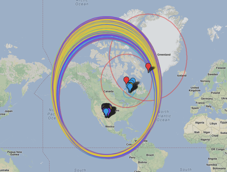
For example, this query (note the “query by points only” option):
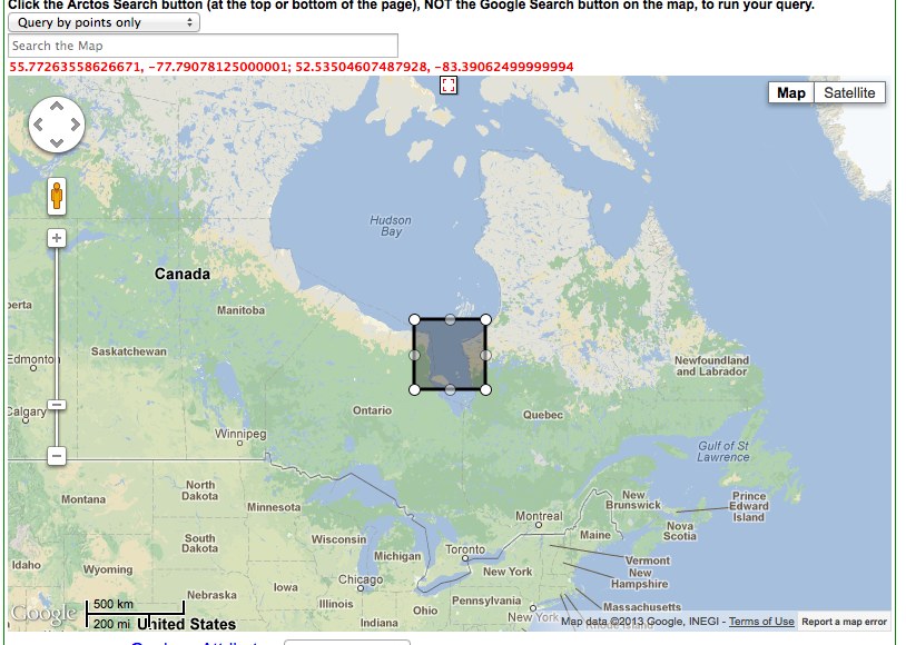
produces these results:
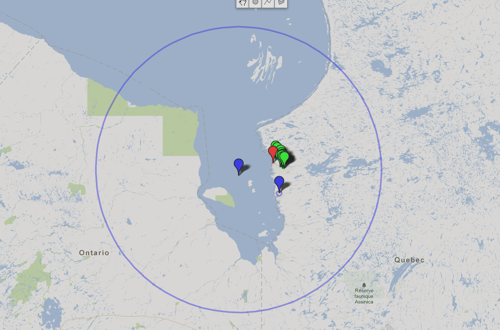
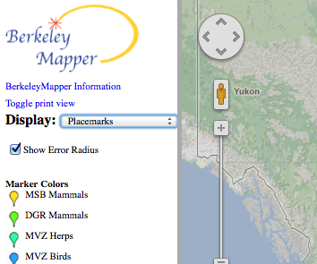
Note that BerkeleyMapper does not by default include precision or remember your settings, so you must enable it every time:
Feel free to stop by and leave a comment on this issue!
Change the original query to “points and error”….
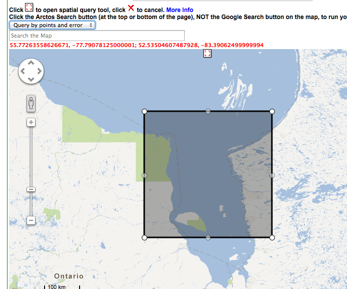
we get….
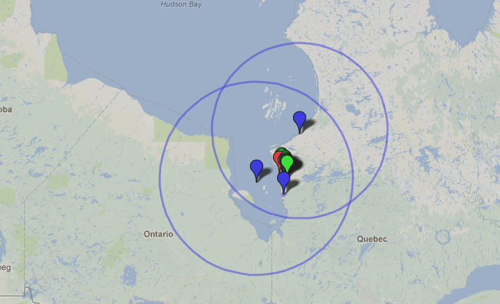
To remove the huge-error specimens, we can add a maximum coordinate precision value:
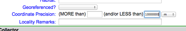
which results in:
Coordinates as Specimen Search terms
Search term “coordinates” matches a full-precision dec_lat,dec_long concatenation.
Search term “rcoords” matches a round(dec_lat,1),round(dec_long,1) concatenation.
Search term “rcoordslist” accepts a pipe-delimited list of rcoords.
Tools
https://www.engineeringtoolbox.com/utm-latitude-longitude-d_1370.html will batch-convert northern hemisphere UTM to DD.dd format.
Edit this Documentation
If you see something that needs to be edited in this document, you can create an issue using the link under the search widget at the top left side of this page, or you can edit directly here.